


In this insightful interview with Automotive Industries, Peipei Zhao, President of North America for RoboSense, delved into the promising future of LiDAR technology for autonomous vehicles and shared exciting product announcements. LiDAR, a Light Detection and Ranging sensor, is vital for enhancing automated driving systems in both Advanced Driver Assistance Systems (ADAS) and Autonomous Vehicles (AVs). It offers high-fidelity signals for recognizing objects around the vehicle, ensuring precise distance measurements even in challenging conditions, thus improving decision-making in automated systems.
The adoption of LiDAR in consumer vehicles is expected to soar from 0.64% in 2023 to over 5% by 2028 and 10% by 2033. RoboSense, leading the industry, was the first to achieve mass production for automotive OEMs in North America. They have been working with a prominent American EV company since 2021, with thousands of consumer vehicles already equipped with RoboSense LiDAR, significantly impacting road safety.
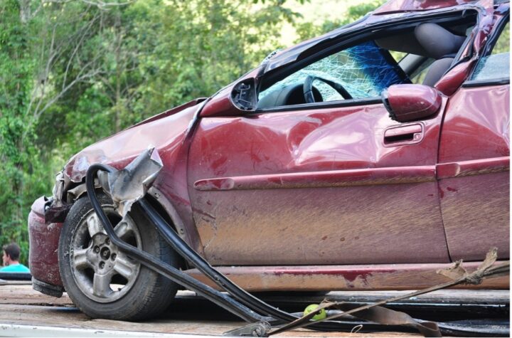
Zhao highlighted the regulatory shift, noting the National Highway Traffic Safety Administration (NHTSA) mandate that by 2029, all U.S. passenger cars and light trucks must feature Automatic Emergency Braking (AEB), including pedestrian AEB. This regulation aims to reduce rear-end and pedestrian crashes, potentially saving 360 lives and preventing 24,000 injuries annually. LiDAR’s precise 3D mapping and detection capabilities are crucial in enhancing AEB performance, thereby reducing accidents and fatalities.
RoboSense’s latest products, the M3 long-range LiDAR sensor and the MX mid-range LiDAR sensor, are set to drive mass adoption in Level 2 to Level 3 beyond vehicles globally. The M3, with its 940 nm wavelength, achieves a 300-meter range at 10% reflectivity, offering a compact, cost-effective, and power-efficient solution. Its proprietary 2D scanning technology provides exceptional angular resolution, improving intelligent vehicle systems. The MX, the industry’s first full-stack system-on-chip LiDAR, will enter mass production in early 2025. With a slim design, lower power consumption, and a 200-meter range, it offers enhanced safety and efficiency, making high-performance LiDAR accessible to entry-level car models.
Zhao emphasized RoboSense’s competitive edge through its in-house chip technology and full-stack perception solutions. Their proprietary chip technology ensures seamless integration between hardware and software, reducing costs and enhancing performance. The full-stack solutions include LiDAR sensors and software for data processing, providing accurate real-time data for improved decision-making, safety, and efficiency. Additionally, their innovative GAZE technology dynamically adjusts perception focus, crucial for navigating complex urban environments.
The V2X Vehicle-to-Road Synergistic Perception System, powered by LiDAR, extends perception capabilities beyond onboard sensors by integrating data from roadside units and other vehicles. This multi-source data improves accuracy, reduces errors, and provides real-time updates on traffic and hazards, enhancing autonomous vehicle safety and efficiency, especially in adverse conditions.
RoboSense’s fusion technology, combining LiDAR and cameras, further enhances the accuracy and reliability of perception systems in autonomous vehicles. This integration leverages the strengths of both technologies, providing precise 3D spatial information and rich visual details, ensuring robust performance across various environmental conditions.
RoboSense’s advancements in LiDAR technology and their strategic approach to integration and regulation are poised to significantly enhance the safety and efficiency of autonomous driving, paving the way for smarter, safer transportation solutions.
Automotive Industries interview with Peipei Zhao, President, North America, RoboSense LiDAR
Automotive Industries: Hi Peipei, can you discuss the future of LiDAR technology for autonomous vehicles and any upcoming product announcements from RoboSense?
Zhao: LiDAR, a Light Detection and Ranging sensor, is essential for improving automated driving systems in both ADAS and AV. It provides high-fidelity signals for recognizing objects around the vehicle, even in darkness and challenging environments. LiDAR measures distances precisely, enhancing decision-making in automated systems. The LiDAR industry is crucial for both the auto industry and overall road safety. In 2023, only 0.64% of consumer vehicles had LiDAR, but this rate is expected to exceed 5% by 2028 and 10% by 2033 (Yole Intelligence Report, “LiDAR in Automotive,” July 2023).
RoboSense is the first LiDAR company to reach mass production for automotive OEMs in North America, and demand continues to grow. By working with a leading American EV company since 2021, there are already thousands of consumer vehicles equipped with RoboSense LiDAR on the road, helping to save lives and making a major impact within the industry. Given its safety benefits, LiDAR is shifting from a desirable feature to a mandatory component in the automotive industry because of its ability to provide accurate, real-time data that enhances safety, efficiency, and the overall driving experience, especially in high-speed conditions.
In fact, the NHTSA has recently mandated, that by 2029, all U.S. passenger cars and light trucks must have automatic emergency braking (AEB), including pedestrian AEB. This regulation aims to reduce rear-end and pedestrian crashes, which could help to save at minimum 360 lives and prevent approximately 24,000 injuries annually. AEB technology detects and automatically brakes for vehicles and pedestrians, ensuring safer travel. LiDAR’s precise 3D mapping and detection capabilities improve AEB performance, helping achieve the goal of reducing accidents and fatalities, ultimately providing consumers with safer roads.
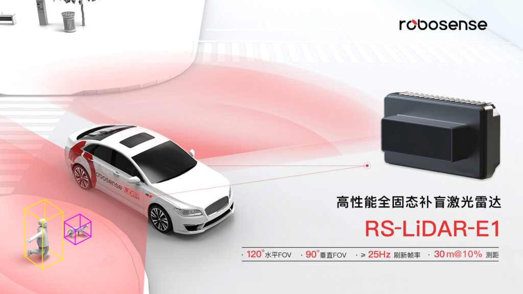
To continue meeting industry and customer demands, RoboSense announced two market-leading products this year: The M3 long-range LiDAR sensor and mid-range product, MX LiDAR.
- M3: The first long-range sensor, the M3 a big step forward as RoboSense drives mass adoption of their automotive-grade sensors in Level 3 (L3)+ vehicles globally. The M3 is a disruptive technology that rivals incumbent long-range 1550nm sensors by using 940 nm wavelengths to achieve 300m range at 10% reflectivity, and delivers a more compact, cost-effective, power-efficient sensor. Additionally, the M3’s proprietary 2D scanning technology enables a 0.05° x 0.05° angular resolution within the region of interest (ROI) to detect smaller objects at longer distances, improving intelligent vehicle systems.
- MX LiDAR: The industry’s first full-stack, system-on-chip, the MX will enter mass production in early 2025. With a slim 25mm design, ultra-quiet operation, lower power consumption and reduced cost, it offers a 200M range and enhanced driving safety and efficiency. Compared to previous models, the MX is 44% thinner, providing OEMs with more packaging flexibility, and the cost makes it suitable for entry-level car models. It is critical to make LiDAR affordable for entry-level consumer vehicles because we believe safety should not be exclusive to luxury vehicles.
Automotive Industries: RoboSense is known for its in-house chip technology and full-stack perception solutions. How do these elements give RoboSense a competitive edge in the autonomous vehicle market?
Zhao: RoboSense is known for its in-house chip technology and full-stack perception solutions, which offer significant advantages in the autonomous vehicle market. Here’s how these elements address industry and customer pain points, providing RoboSense with a competitive edge:
- In-House Chip Technology: RoboSense’s proprietary chip technology creates specialized hardware tailored for their LiDAR systems. This in-house development ensures seamless integration between hardware and software, enhancing performance, reliability, and reducing dependency on external suppliers. This independence enables faster iterations and efficient production scaling, meeting the need for rapid development of high-performance LiDAR systems. It also reduces costs and improves efficiency, making high-performance LiDAR solutions more cost-effective. LiDAR design involves scanning chip technology, iterative transceiver modules, and integrated data processing. RoboSense focuses on the scanning chip aspect and overall SoC. The supply chain for transceiver modules is robust, with numerous chips available for data processing.
- Full-Stack Perception Solutions: RoboSense’s solutions include LiDAR sensors and software for data processing and interpretation, ensuring seamless integration with vehicle systems. This provides accurate real-time data crucial for autonomous driving, improving decision-making, safety, and efficiency. The integration of hardware and AI-driven software enhances system functionality, addressing the need for robust perception systems in autonomous vehicles. The solutions are flexible and scalable, allowing customization to meet specific vehicle platform needs, ensuring high performance and accuracy in diverse driving scenarios.
- ROI and GAZE Technology: RoboSense’s innovative GAZE technology dynamically adjusts perception focus based on the region of interest (ROI), ensuring precise and stable environmental data. This is beneficial in high-speed and complex urban driving environments, where real-time, precise data is critical for safe navigation. The GAZE function enhances vertical angular resolution and frame rate, significantly improving the detection of small obstacles and system responsiveness. This high-performance perception capability is essential for navigating mixed traffic and adverse weather conditions, enhancing overall driving safety.
By leveraging these strengths, RoboSense maintains a competitive edge and significantly contributes to the advancement and safety of autonomous driving technology. Their solutions accelerate the adoption of autonomous vehicles across various industries, including transportation, logistics, and mobility, by providing reliable, high-performance perception systems.
Automotive Industries: How does the V2X Vehicle-to-Road Synergistic Perception System enhance the perception capabilities of autonomous vehicles compared to traditional systems?
Zhao: The V2X Vehicle-to-Road Synergistic Perception System enhances autonomous vehicle perception by extending range beyond onboard sensors and integrating data from roadside units and other vehicles. This multi-source data improves accuracy and comprehensiveness, reducing errors. V2X systems provide real-time updates on traffic, hazards, and vehicle actions, enabling better anticipation and reaction to changes. Faster data exchange reduces latency, crucial for collision avoidance and improved response times. Additionally, V2X systems maintain reliable perception in adverse conditions like rain, fog, or darkness, where traditional sensors might struggle. Overall, it offers a more accurate and reliable understanding of the driving environment, surpassing traditional systems.
LiDAR technology empowers the V2X Vehicle-to-Road Synergistic Perception System by extending range, improving accuracy, and enhancing situational awareness, significantly boosting autonomous vehicle perception. LiDAR creates detailed 3D maps and integrates with V2X to share data, allowing precise detection of objects at greater distances. Its high-accuracy measurements can be cross-verified with V2X data, reducing errors. LiDAR’s continuous scanning and data fusion with V2X provide a comprehensive understanding of the environment. Fast data processing and real-time communication reduce latency, crucial for collision avoidance. Reliable in poor visibility, LiDAR complements V2X information in adverse conditions, ensuring consistent perception. Without LiDAR, autonomous vehicles would heavily rely on other sensors, limiting their perception capabilities, especially in adverse weather and complex traffic environments. Overall, LiDAR offers accurate and reliable environmental data, surpassing traditional systems.
The V2X Vehicle-to-Road Synergistic Perception System by RoboSense offers a groundbreaking “Bird’s eye view” of road conditions, surpassing traditional systems. By integrating data from multiple LiDAR base stations and cameras, it provides real-time true color point cloud data for enhanced awareness. Key features include multi-base station LiDAR fusion, dynamic electronic fences, and advanced traffic flow statistics. This comprehensive road condition awareness ensures greater safety and supports the development of intelligent transportation infrastructure.
Automotive Industries: Could you explain how RoboSense’s multi-base station and multi-LiDAR fusion technology works and its benefits for autonomous driving?
Zhao: RoboSense’s multi-base station and multi-LiDAR fusion technology integrates data from multiple LiDAR sensors and base stations to create a unified, synchronized perception of the environment. Here are four key benefits for autonomous driving:
- Improved Accuracy and Reliability: By integrating data from multiple LiDAR sensors and base stations, the system cross-verifies information, reducing errors and enhancing environmental perception accuracy. This comprehensive 3D mapping ensures a reliable understanding of surroundings, crucial for safe autonomous driving.
- Extended Coverage and Range: The multi-base station setup allows for extended coverage, ensuring continuous data collection over large or complex environments. This is beneficial in high-speed or urban driving scenarios, where maintaining broad and detailed perception is essential for safety and navigation.
- Real-Time Data Fusion: The system provides real-time updates on traffic, obstacles, and other critical information through fast data processing and real-time communication. This capability is crucial for collision avoidance, enhancing the vehicle’s ability to react quickly to environmental changes.
- Enhanced Performance in Adverse Conditions: RoboSense’s fusion technology ensures reliable perception even in challenging conditions like rain, fog, or darkness. By combining LiDAR data with inputs from other sensors like cameras, the system maintains high performance and consistent environmental awareness, overcoming limitations of traditional sensors.
By leveraging these strengths, RoboSense enhances autonomous vehicle perception systems, contributing to safer and more efficient transportation solutions.
Automotive Industries: What role does the AI Perception Software play in the V2X system, and what specific traffic functions does it support?
Zhao: When it comes to V2X systems, AI Perception Software plays a key role, especially when integrated with RoboSense LiDAR technology. Here’s how it works and the specific traffic functions it supports:
- Seeing the World Clearly: With RoboSense LiDAR providing high-resolution 3D data, the AI Perception Software gets a crystal-clear view of the surroundings. It can detect and classify objects like cars, pedestrians, and even small obstacles with incredible accuracy.
- Smart Predictions and Quick Decisions: The software uses advanced machine learning to predict how other road users will move. Paired with precise LiDAR data, it can make real-time decisions to keep everyone safe and traffic flowing smoothly.
- Reading Signals and Staying in Lane: AI software is great at recognizing traffic signals, signs, and lane markings. RoboSense LiDAR enhances this by working reliably even in tough conditions, making sure the vehicle follows traffic rules and stays in its lane.
- Avoiding Collisions and Cruising Smoothly: Thanks to the detailed data from RoboSense LiDAR, the AI can spot potential collisions early and take action, like automatic braking or steering. It also adjusts the car’s speed to keep a safe distance from others, ensuring a smooth and safe drive.
Automotive Industries: How does RoboSense’s LiDAR and camera fusion technology improve the accuracy and reliability of perception systems in autonomous vehicles?
Zhao: RoboSense’s LiDAR and camera fusion technology significantly enhances the accuracy and reliability of perception systems in autonomous vehicles through several key mechanisms.
By combining data from LiDAR and cameras, the perception system leverages the strengths of both technologies. LiDAR provides precise 3D spatial information about the environment, while cameras offer rich visual details and color information. Integrating these data sources allows for a more comprehensive understanding of the surroundings, improving object detection and classification.
LiDAR excels in adverse weather conditions such as rain, fog, or low light, where cameras may struggle to provide accurate data. By fusing LiDAR data with camera images, the perception system becomes more robust and reliable across a wide range of environmental conditions. This ensures consistent performance and safety for autonomous driving in various scenarios.
The fusion of LiDAR and camera data enables more accurate detection and tracking of objects on the road, including vehicles, pedestrians, and cyclists. LiDAR provides precise distance measurements and 3D spatial information, while cameras offer additional visual cues such as shape and texture. By combining these sources of information, the perception system can better discern objects and anticipate their movements, enhancing overall safety and decision-making.
Integrating LiDAR and camera data helps mitigate the limitations of each technology individually. LiDAR’s precise measurements complement the camera’s visual information, providing a more accurate and reliable perception system. For example, LiDAR can accurately detect objects at far distances, whereas cameras may struggle with depth perception in certain conditions. By fusing these data streams and cross-referencing their outputs, the perception system can reduce the occurrence of false detections and improve overall accuracy.
In summary, RoboSense’s LiDAR and camera fusion technology improves the accuracy and reliability of perception systems in autonomous vehicles by combining complementary data sources, enhancing robustness to environmental conditions, enabling more precise object detection and tracking, and reducing false positives and negatives. This contributes to safer and more efficient autonomous driving experiences.
Automotive Industries: What are the advantages of RoboSense’s V2X vertical and horizontal mounting schemes for urban infrastructure and traffic management?
Zhao: RoboSense’s V2X vertical and horizontal mounting schemes offer urban infrastructure and traffic management several advantages. Vertical mounting extends detection range and accuracy by integrating LiDAR sensors with traffic lights, facilitating real-time monitoring and adaptive signal control. Horizontal mounting ensures 360-degree coverage, minimizing blind spots and enhancing safety. These schemes provide cost-effective solutions, leveraging existing infrastructure while delivering advanced sensing capabilities for efficient traffic management.
Automotive Industries: Can you provide more details about the Open Road V2R Project and its impact on smart transportation and road safety?
Zhao: The Open Road V2R (Vehicle-to-Road) Project represents a groundbreaking initiative in smart transportation and road safety, particularly in its approach to addressing challenges in closed areas compared to open road environments. In closed areas, such as construction zones or parking lots, traditional communication technologies often face obstacles like signal interference or limited coverage. The Open Road V2R Project overcomes these challenges by utilizing LiDAR technology, which offers precise 3D mapping and object detection capabilities. Unlike traditional communication methods, LiDAR provides real-time, high-resolution data regardless of environmental conditions, ensuring reliable communication and accurate situational awareness in closed areas.
However, LiDAR’s importance becomes even more pronounced in open road segments, where it becomes virtually mandated. In these environments, where vehicles operate at higher speeds and encounter a wider range of obstacles and hazards, LiDAR plays a critical role in ensuring safety and efficiency. Its ability to accurately detect objects over long distances and in various lighting conditions becomes indispensable for autonomous vehicles and advanced driver assistance systems (ADAS). LiDAR’s mandate in open road segments underscores its significance in enhancing road safety and enabling the successful deployment of smart transportation solutions.
LiDAR’s ability to detect objects with high accuracy enhances road safety in closed environments by enabling vehicles to navigate through complex obstacles and avoid collisions. Moreover, LiDAR facilitates efficient traffic management by providing detailed information about vehicle movements and road conditions, contributing to smoother traffic flow and reduced congestion.
Overall, the Open Road V2R Project demonstrates the transformative impact of LiDAR technology on smart transportation and road safety, particularly in overcoming challenges associated with closed areas. By leveraging LiDAR’s advanced capabilities, the project not only enhances safety but also paves the way for more efficient and reliable transportation systems in urban environments.
Automotive Industries: How is RoboSense integrating 5G technology with its Smart Bus Road Collaboration to enhance the V2R Smart Road System?
Zhao: RoboSense LiDAR, combined with 5G, greatly enhances the V2R (Vehicle-to-Road) Smart Road System:
- High-Speed Data Transmission: 5G’s high bandwidth and low latency enable rapid, real-time transmission of RoboSense LiDAR data for quick decision-making and response.
- Enhanced Situational Awareness: RoboSense LiDAR continuously monitors the environment, and 5G transmits this data, providing up-to-date road conditions and improving safety.
- Cooperative Perception: 5G integrates RoboSense LiDAR data with other sensors, creating a comprehensive view and a collaborative network. RoboSense LiDAR can cross-verify data from other sensors, ensuring greater accuracy.
- Advanced Traffic Management: RoboSense LiDAR and 5G offer real-time traffic data, supporting dynamic control and optimization, enhancing efficiency.
- Enhanced Safety Features: 5G enables RoboSense LiDAR to detect and avoid collisions more effectively, with rapid communication in emergencies improving response.
More Stories
Sensor Fusion and the Next Generation of Autonomous Driving Systems
Unique Experiences in Miami: What to Do Off the Beaten Path
The Factors That Impact the Outcome of a Car Accident Claim